NANAIMO RIVER – CAN IT SURVIVE NANAIMO?
by
Ted Burns
I’m standing at the tip of Jack Point. It’s a cool August night and the lights of Nanaimo are a lovely kaleidoscope to the west. To the east, a full moon is rising over Gabriola Island and the lights of houses are blinking above the bluffs that drop sharply into Northumberland Channel. The only sounds are waves, lapping on the rocks and muffled machinery at Doman’s Mill to the southeast at Duke Point.
Its a calm, peaceful scene but one that belies the reality of Nanaimo; the town with the beautiful name and lovely setting that has turned ugly with its cascading sprawl of suburbia as it rushes hard into the next century.
Nanaimo has long been known as a city without an environmental conscience. Nanaimo River estuary lies just south of Duke Point. In 1971, Nanaimo Harbour Commission wanted to turn it into an industrial port by dredging and paving it. Every biologist in Nanaimo, and there is an impressive number due to the presence of the Pacific Biological Station at Departure Bay, signed a petition that was published in the Nanaimo Free Press. This and public pressure thwarted the Commission and the facility was located at Duke Point. It was the first and last time that many of the scientists at the station came out of their closets.
For many years, Nanaimo was run by a mayor and council that favoured unfettered development. Their vision of prosperity consisted of a series of malls, gas stations and fast food outlets strung along the Island Highway and an endless parade of housing tracts rolling into the hinterlands. Some of them reached as far as the Nanaimo River which is well south of the city. Frank Ney was the Mayor and president of Nanaimo Realty. He was a loveable, good hearted man (Frank died in 1992) but his vision of Nanaimo was strongly coloured by his developer instincts. It wasn’t difficult to get the feeling that town planning was being done by Nanaimo Realty. The Nanaimo Regional District seemed to mirror Nanaimo City Council in terms of their vision of the future.
But Nanaimo is shedding its image as a developers paradise. Recent city councils have been far more sensitive to environmental concerns. They recently passed a stream protection bylaw an environmental protection officer is on staff . Plan Nanaimo, a comprehensive framework for a new community plan, is in the mid-stages of public input. The plan presents a number of scenarios for the future structure of the city. Most of these include an urban containment boundary which roughly coincides with the present limits of Nanaimo. That is superb news for Nanaimo River.
Nanaimo River is perhaps the most beautiful stream on the East Slope of Vancouver Island. It begins in high sub-alpine country near the centre of the Island just east of the Upper Nitinat River and heads west for some seventy kilometres to its estuary dropping some twelve hundred metres along the way. It gathers flow from a number of major tributaries such as Sadie Creek, Green River, Deadwood Creek, its South Fork and Haslam Creek as it tumbles east. Several good sized lakes buffer winter discharge and help warm its summer flow.
Nanaimo River supports chinook, coho and chum salmon in substantial numbers and a few pink salmon and an occasional sockeye. Prior to the mid-fifties, pinks were rather abundant, particularly in Lower Haslam Creek. Runoff from coal mining waste is said to have doomed the pink run. Steelhead are also abundant and sea-run and resident cutthroat trout are also present, particularly in small tributaries of the Lower River and estuary like Thatcher, Beck and Holden Creeks. Resident rainbow trout are present throughout the river and in the lakes and Dolly Varden are resident in headwater portions of the system.
The river is most noted for its chinook and steelhead runs. There is a rather unique spring run of chinooks that begins entering the river as early as March and a sometimes strong fall run that contains some very large fish. Steelhead are represented by a winter and spring run.
Steelhead are the main target of anglers. The river is one of the best steelhead streams on Vancouver Island, usually ranking in or near the top five in terms of catch and effort. Although steelhead can penetrate well into the upper river (some 55 km on the mainstem), most angling occurs in the lower 12.5 km between the Bore Hole and the estuary. In that area, the majority of angling takes place in a 5 km section between the Bore Hole and the Haslam Run near the mouth of Haslam Creek.
Fishing is not the only Nanaimo River recreational attraction; far from it. On warm summer weekend days, as many as five thousand people may be swimming and sunbathing along the river all the way from Cedar Bridge up to the Glade Pool not far below First Lake. Because of the lakes and perhaps because of the large amount of heat absorbing bedrock canyon between First Lake and the highway bridge, Nanaimo River is Vancouver Islands’ warmest. Summer temperatures sometimes reach 25 degrees much to the delight of its’ legion of swimmers.
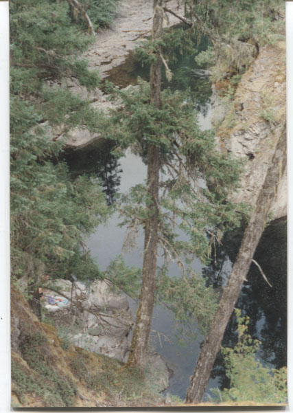
Although a large percentage of swimmers frequent the Highway Bridge Pool, Pumphouse Pool and Cedar Bridge Pool, many others seek more secluded upstream havens in the rivers’ lovely canyon section. River Terrace, the Old Comox Logging Railroad Trestle area, White Rapids, the Gunbarrel and Staircase, Top Shelf and Bottom Shelf near the old White Rapids mine, Kinnikinnick Canyon, the Goat Trail Pool, Boulder Garden, Golden Fields and White Rocks, Long Rope Pool, South Fork Pool, Quarry Pool, Ocean Spray Pools, Big Bend, Ninebark Pool and the Glade Pool attract an earthy clientele along with a strong showing of the muscle, beer and bikini crowd.
This section of Nanaimo River is its finest and the one that sets it somewhat apart from many other Island streams in terms of beauty. Most of it is reached via Nanaimo River Road and numerous side roads and trails. Some side roads lead to traditional camping areas as well as swimming and fishing spots. All these roads are on private property owned by TimberWest or Island Timberlands. Vehicle access has been cut off due to vandalism and garbage dumping. This is no great loss to swimmers and anglers because the walks are not far but RV campers bemoan the loss of some world class riverside camping spots.
There is a need for much closer management of the Nanaimo River Corridor which extends from the estuary to First Lake. In all that distance (33 kms) through all that beauty and areas of intense use, there is not a single park or recreation area (the closest thing is the Cassidy Rest Stop at the highway bridge). Not a single square millimetre of ground protected from development and managed for outdoor recreation; this seems inconceivable. The corridor cries out for attention and management.
A number of old right of ways parallel the River Corridor. Of particular importance is the Comox Logging and Railroad Grade which is owned by Timberwest. It runs along the north side of the river from the trestle 1.4 km above the Bore Hole to First Lake and, for much of its length, it forms the north boundary of Nanaimo River Corridor. Park dedication of the right of way and the corridor lands south of it including lands on the south side of the river, would be a major step toward giving the river the attention it deserves. A number of smaller parks or recreation sites could be established downstream at places like the Bore Hole, Forestry Run, Haslam Run and Thatcher Creek – Morden Park Area and a special zoning status should be applied to the corridor outside the parklands to insure that no more development invades land that rightly belongs to the river not the real estate market place
.
Tags: real estate instincts